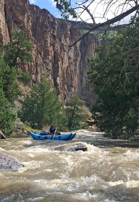
Jarbidge River
Idaho
The Jarbidge River originates as two main forks in the Jarbidge Mountains of northeastern Nevada. It flows through basalt and rhyolite canyons on the high plateau of the Owyhee Desert before joining the West Fork of the Bruneau River to form the Bruneau River about 24 miles north of the Nevada border, just upstream of Indian Hot Springs. Nearly 29 miles are designated wild. Challenging whitewater flows through a canyon with steep walls and statuesque rock formations. Golden eagles are often seen, and chukar are abundant.
Designated Reach
March 30, 2009. The Jarbidge River from its confluence with the West Fork of the Bruneau River to the upstream boundary of the Bruneau-Jarbidge Rivers Wilderness.
Outstandingly Remarkable Values
Botany
The Bruneau River phlox, a white-flowered and matted plant that clings to ledges, rock crevices, and cliffs, occurs in vertical or overhanging rhyolitic canyon walls along the inner Jarbidge River Canyons. The entire known extent of Bruneau River phlox in Idaho occurs within approximately 35 miles on the Bruneau, West Fork of the Bruneau, and Jarbidge Rivers.
Fish
The Jarbidge River supports both redband trout and the southernmost population of bull trout in North America and contains one of six bull trout populations identified for recovery. The threatened bull trout is the only fish in the Owyhee Canyonlands that is federally listed under the Endangered Species Act. Jarbidge River bull trout are important because they occupy a unique and unusual semi-arid desert ecological setting, and their loss would result in a substantial modification of the species’ range.
Although bull trout spawn in upstream portions of the Jarbidge River in Nevada, the designated segment contains bull trout over-wintering and migratory habitat. Bank-full flows move the riverbed materials downstream, and the silts and sands to upper channel banks, making for good bull trout habitat. The bull trout and redband trout populations also thrive on low flows that maintain hiding pools that hold water throughout dryer seasons.
Geology
The Jarbidge, Bruneau and Owyhee river systems provide the largest concentration of sheer-walled rhyolite/basalt canyons in the western United States. Though not unique to southwest Idaho, the presence of these geologic formations in such great abundance and aerial extent makes the designated river segments geologically unique from a national perspective.
The geology of the canyons has been shaped by a combination of volcanic activity, glacial melt, and regional drainage patterns. The Bruneau-Jarbidge and Owyhee areas were the sites of the massive Owyhee-Humboldt and Bruneau-Jarbidge volcanic centers, whose explosions, massive rhyolite flows, basaltic eruptions, and related glacial flows carved out their spectacular canyons. Where overlying basalt is present, the rhyolite formations are nestled in the rubble slopes below vertical walls of basalt. Weathering and erosion have carved immense monolithic cliffs and numerous sculptured pinnacles known as “hoodoos.”
There is one small-scale jasper-mining claim near Indian Hot Springs in the Bruneau River Canyon, just downstream of where the Jarbidge flows into the Bruneau.
Prehistory
Native Americans have utilized the canyonlands for shelter, weaponry, fish and game, and water for thousands of years. Petroglyphs, pictographs, rock alignments, shrines, and vision quest sites of the Shoshone and Paiute peoples are located throughout the Owyhee Canyonlands. Tribal members still frequent the canyonland areas to hunt, fish, pray, and conduct ceremonies.
A Native American legend about a dangerous creature that lived in the Jarbidge Canyon supports the idea that ancient peoples avoided living there long-term. The creature was called Tsa-hau-bitts or Jahabich, loosely translating to “evil spirit.” Through many English interpretations of these names, the area eventually became known as Jarbidge.
Recreation
The Jarbidge River is a narrow, technical river known nationally for its challenging whitewater through a remote desert canyon. Boats over 14' are not recommended for there are two or more long, rocky, and challenging portages. Additional hazards on the Jarbidge are ever-changing logjams and blind corners. Given the four-wheel drive, high-clearance vehicle required to travel to the Jarbidge River takeout, most paddlers continue on to the Bruneau.
Scenery
Narrow canyons along the Jarbidge River can be as deep as 800 feet. They are dominated by a mixture of high, vertical lines, and forms of coarse-textured, red, brown, or blackish eroded cliffs, often glazed with yellow to light green micro-flora. Steep diagonal lines of talus slopes, with their yellow and subdued green sagebrush-bunchgrass communities, dark green juniper, medium-textured, reddish rhyolite rubble fields and coarse-textured, blackish basalt rubble fields, add visual variety. The combinations of line, form, color, and texture found amidst this close association of landforms, water, and vegetation create exceptional landscapes.
Wildlife
The Owyhee Canyonlands provide riparian habitat for a number of wildlife species common to southwest Idaho. Big game commonly found in the area includes California bighorn sheep, elk, mule deer, and pronghorn.
Common large and mid-sized predators in the area include cougars, bobcats, coyotes, badgers, and raccoons. Small mammals include rodents (mice, kangaroo rats, voles, squirrels, and chipmunks), rabbits, shrews, bats, weasels, and skunks. River otters are supported by year-long flows and a good prey base (fisheries). Birds include songbirds, waterfowl, shorebirds, and raptors.
This area includes Preliminary Priority Habitat for greater sage-grouse and a number of Idaho BLM sensitive species, including bald eagle, yellow-billed cuckoo, prairie falcon, ferruginous hawk, several neotropical migratory bird species, several bat species, Columbia spotted frog, and western toad. Cliffs also support spotted and Townsend’s big-eared bats.

