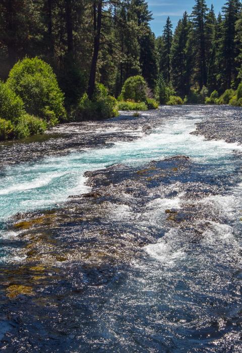
Metolius River
Oregon
Nestled in a forested valley on the east side of the Cascade Mountain Range in central Oregon, the Metolius River gushes full-grown from the spectacular springs at its headwaters and is one of the largest spring-fed rivers in the United States. Its clear, cold, and constant waters support nationally renowned blue ribbon flyfishing along with whitewater boating. Other recreational opportunities include fish viewing, camping, sightseeing, hiking, hunting, and mountain biking. The lower river, adjacent to the Warm Springs Indian Reservation, is managed as a primitive area with no motorized access.
As it flows through memorable stands of old-growth ponderosa pine, it is as cherished by the thousands who visit it annually from across the nation as it is by the Native Americans who share in the traditions and administration of this rare resource.
Designated Reach
October 28, 1988. From the Deschutes National Forest boundary to Lake Billy Chinook.
Outstandingly Remarkable Values
Ecology
Ecological values include landscape-level gradients of environmental factors as the river travels through a transition zone from the forested Cascades to the desert Great Basin; the disjunct populations of west-side species associated with Green Ridge; unique plant species; and the variety of riparian habitats, including unique vegetated islands.
Fish
The cold, clean water and stable flow creates unique aquatic habitats for the fish of the Metolius River. The river is noted in-state and nationwide for trout fishing, with the clear spring-fed water and scenic views of the Cascade peaks through large ponderosa Pines an important part of the experience. Wild rainbow trout, hatchery rainbow trout, and a now-thriving bull trout population have drawn anglers to the Metolius River for years.
Geology
The geologic condition of the area is unique within the region. The Green Ridge Fault is the primary evidence for a large graben in the High Cascades and causes a large number of springs to develop, a condition unique to the Cascade Range. (A graben is an elongated block of the earth’s crust lying between two faults and below the blocks on either side, as in a rift valley.) Other rivers in the region, such as Fall River and Spring River, are spring-fed, but the springs on these rivers appear on the surface due to different subsurface geologic conditions than are found in the Metolius. The Metolius River area is used as an example of the interplay of faulting, volcanism, and groundwater hydrology in many college-level geology classes and is listed in well-recognized field guides and geologic literature. Many groups use the Metolius as a stopping place for geologic tours.
History
The distinct, varied history of early exploration by trappers, homesteading, early recreation use, Civilian Conservation Corp use, and early Forest Service administration are unique within the region. In the corridor, there is a site eligible for the National Register of Historic Places, and other sites and areas might be eligible when/if evaluated.
Hydrology
The Metolius River has extremely high water quality water over the full length of the river. While the spring-fed nature of the river is found on other rivers in the region, such as the Cultus River, Fall River, and Spring River, these rivers do not maintain comparable quality over the length of the river. The Metolius River is the largest spring-fed river in the region, has the steepest gradient drop of the spring-fed rivers, and experiences a unique drop in downstream water temperatures. The consistent, sustained flows, and the stability of the Metolius River system, are also unique when compared to other rivers in the region.
Native American Traditional Use
Traditional uses, recognized through treaty and tribal code, continue into the present day. Priorities for the tribes are to ensure that the Metolius, used by people over the past 10,000 to 12,000 years, remains part of their culture and to raise the level of importance and knowledge of that culture.
Prehistory
Sites with evidence of occupation and use predating the eruption of Mount Mazama and other geologic episodes, and the evidence of use by more than one cultural group, are criteria which contribute to the significance of archaeological properties within a regional perspective. All known lithic scatter sites within the Metolius River corridor are considered eligible for the National Register of Historic Places.
Recreation
Visitors who come to the Metolius River are able to participate in a full spectrum of recreational opportunities. The rich mix of both dispersed and developed recreational opportunities that is available in the upper 8-10 miles of the river, combined with the change in character to a dispersed primitive setting on the lower portion of the river, is unique to the region.
Scenery
Aesthetic qualities include the appearance, sounds, and smells of the river corridor that contribute to its appearance. The rustic recreational river segment and primitive scenic river segment contain many outstanding features, including the unique extent and context of the foreground landscape within a ponderosa pine forest, the diversity of views over the length of the river, the lack of significant modifications of the view over the full length of the river, the rustic character of the existing buildings (which generally blend well with elements found in the natural landscape), and the area’s reputation for spectacular views. The visual prominence of the Metolius River is a well-known scene for many visitors throughout the state and the nation.
Wildlife
A diversity of resident and migratory wildlife species is present in high-quality riparian and old-growth forest habitats in and near the Metolius corridor. The wildlife values identified include the presence of federally listed threatened and endangered species. The river-related habitat diversity is exemplary, resulting from a mix of ponderosa pine, mixed conifer old growth, riparian, meadow, riverine, and aquatic habitats. The corridor provides an important east/west link between winter and summer ranges for mule deer and elk and a contiguous habitat link for other animals.

