Sturgeon River (Hiawatha National Forest)
Sturgeon River (Hiawatha National Forest)
Michigan
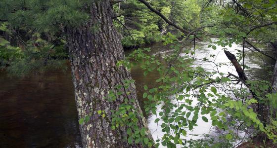
The Sturgeon River, in Michigan's Upper Peninsula, has outstanding wildlife, heritage, ecological, and hydrologic resources. It is one of the few areas on the Upper Peninsula with a southern-floodplain microclimate where a diverse community of plants and animals thrive. Viewsheds along the Sturgeon River are very confined due to the heavy streambank vegetation. Consequently, the natural-appearing characteristics of the landscape dominate. Visitors experience minimal evidence of human development in the scenic segment and slightly more human development and modification of the landscape in the recreational segment.
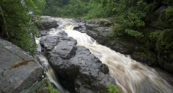
Early summer and late fall are the best times to canoe the Sturgeon River. Two main rapids challenge canoeists, while elusive brown trout, steelhead, and salmon challenge anglers.
The river enters Lake Michigan at the historic town of Nahma.
Designated Reach
March 3, 1992. From the north line of Section 26, T43N, R19W, to Lake Michigan.
Outstandingly Remarkable Values
Botany
The river corridor supports the occurrence of a number of regionally sensitive species including butternut, fir clubmoss, and waxy meadow-rue, among others. It is, however, the large representation of plant species with a distinct southern affinity found within the Sturgeon River's Southern floodplain forest that allows for the distinction as an ecologically significant plant community and a regionally outstandingly remarkable value.
Ecology
The Sturgeon River's southern floodplain forest exists due to the mild microclimate created by the river and is found most predominantly along the southern portions of the Sturgeon. The highly dynamic floodplain created by the river in the lower reaches supports the floodplain forest, which usually occurs in the highly meandered portions of the river valley and is likely maintained by the frequent disturbances caused by channel changes. The southern floodplain forest community slowly grades into a floodplain community more typical of northern environs as one travels north along the river; the environmental gradient decreases and the river meanders less. In addition to the Sturgeon River, only a small number of other southern floodplain forests exit at this latitude; the Sturgeon River supports this unusual community type in an exemplar condition.
History
Historic period sites associated with the logging industry (c.1840s-1940s) are abundant and highly significant. The river corridor contains a variety of logging-related sites that include an excellent representation of different site types and time periods. These range from a water-powered mill started in the 1840s to 1930s logging settlements along railroad grades occupied by various ethnic groups, including Native Americans. Well-preserved remnants of a logging dam built by the Bay de Noquet Lumber Company in the 1880s include extensive embankments and remains of wooden sluiceways. Many historic photographs and documents relating to logging operations along the Sturgeon River are available for research and public interpretation. One of the best-preserved Civilian Conservation Corps sites on the Hiawatha National Forest is also located in the corridor.
Hydrology
The presence and continuous formation of oxbow features in the lower reaches is unusual in the Great Lakes region. Rivers naturally seek to maintain a balance of sediment and flow that most efficiently transports eroded material through the system. Oxbows are an indication of an upset in that balance, specifically the volume of bedload exceeds the capacity of the river flows to transport it downstream. In the case of oxbow lake formation, the river forms cutoff chutes across highly curved meanders, thereby decreasing the length of channel between two points in the river.
Prehistory
Surveys in the corridor have identified many sites that indicate extensive use of the river corridor in the past by Native Americans. Most of these sites are located in the southern reaches of the river corridor where they tend to occur in clusters that correspond to different paleo-shoreline and resource procurement /processing locations. Additionally, there may be a correlation between unique vegetation (e.g., southern floodplain forest) and a high density of prehistoric Native American sites in this area. Archaeological and geological analysis indicates that this Native American use goes back at least 5,000 years.
Wildlife
Species diversity and quality wildlife habitat are prominent features of the Sturgeon River corridor. The wide variety of habitats located within the corridor support, or have the potential to support, several federally listed threatened or endangered species, state-listed species, and regionally sensitive species, including gray wolf, bald eagle, osprey, American marten, black-backed woodpecker, and wood turtle. The river corridor also provides quality habitat for regionally important game species, such as white-tailed deer, black bear, and a diverse community of other common game and non-game species. Human intrusions along the riverine corridor are present only in a few areas.