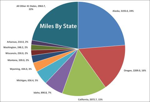
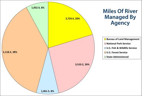
The Interagency Council sets the current number of designated rivers at 228, with 6,452.1 miles classified as "wild," 2,995.4 miles as "scenic," and 4,019.3 miles as "recreational." (Please remember that these classifications have little to do with wilderness, scenery, or recreational use, but are, instead, related to the level of development on the river at the time of designation.) The current calculation is 13,466.8 miles of rivers designated out of the over 2.5 million river miles in the United States.
The miles themselves are likely not 100% accurate. Many of these rivers, especially in Alaska, are very wide, and mileages vary depending on whether measurements were taken on the inside of curves, which channel was measured, etc. Also, most of these mileages are from the legislative language designating the river and were made, in some cases, over 50 years ago when the technology at hand might have been an opisometer (wheel for measuring on maps), a steroscope, or simply a congressional aide with a piece of string and a map with a mileage scale. Still, they are the best numbers we currently have, and many have been updated from the original legislation.
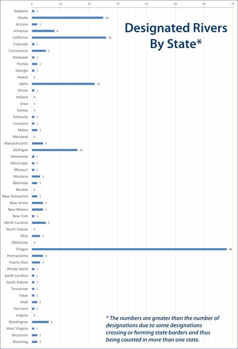
Considerable time has gone into "crunching the numbers" regarding wild and scenic rivers. Because of the nature of the system—rivers with multiple jurisdictions (sometimes by bank), rivers forming state lines, counting or not counting tributaries, etc.—different people can come up with different numbers. For example, one reputable source counts the system at over 400 rivers, because he counts the different rivers designated under one action (e.g., the Klamath River designation in California includes two forks of the Salmon River, the Scott River, and Wooley Creek). We count the Klamath as one designation; he counts it as five. Another example is the Gros Ventre River in Wyoming. One side of the river is the National Elk Range, the other the Bridger-Teton National Forest. Who gets the mileage—the U.S. Fish & Wildlife Service or the U.S. Forest Service? The same "division" problem occurs when a river forms the boundary between two states, like the Snake River in Idaho/Oregon.
We are currently working on a GIS project to more carefully define accurate mileages. Please check back. In the meantime, here are our current best efforts at defining the National System by the numbers.
Excel Spreadsheet River By River