Eagle Creek (Wallowa-Whitman National Forest)
Oregon
The headwaters of Eagle Creek originate high in the glacial cirque in the Eagle Cap Wilderness in the Wallowa-Whitman National Forest. From its beginning at the outlet of Eagle Lake, the creek follows a steep gradient over small waterfalls and whitewater rapids as it descends from the mountains. Vegetation in the classic U-shaped glacial valley alternates between high mountain meadows and stands of subalpine fir and whitebark pine. There are expansive views of the surrounding Wallowa Mountains, and scoured rock outcrops create a highly diverse and dynamic landscape that vies attention with the crystal-clear creek.
The valley floor becomes relatively flat and wide at the Main Eagle Trailhead, and for the next five miles, Eagle Creek temporarily slows in its rapid descent from the high mountains. Clear, blue-green pools alternate with rapids as the creek winds its way through lush green, boulder-strewn meadows and park-like forests. Vegetation and canyon walls generally limit views to the immediate foreground, except for the breathtaking views of the mountains seen from the northern end of the road.
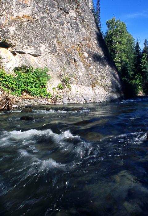
Eagle Creek leaves a landscape dominated by glacial features below its confluence with West Eagle Creek. For approximately the next 10 miles, the valley closes in, and canyon walls become abruptly steep, towering 500-1000' above the valley floor in some places. Eagle Creek resumes its fast-moving, boulder-dominated descent through the narrow canyon, bordered by lush riparian vegetation and picturesque meadows. Dramatic rock formations extending from rim to canyon floor punctuate otherwise forested hillsides. The road paralleling Eagle Creek offers unrestricted views of the creek in the immediate foreground and surrounding hillsides.
As it enters the lower elevation basalt-dominated plateaus surrounding the Wallowa Mountains, the lower seven miles of the designated portion of Eagle Creek take on a character more typical of eastern Oregon rivers. Mixed conifer forests are replaced on drier slopes by grassy openings and park-like stands of ponderosa pine. Unusual rock formations provide visual contrast. By this time, Eagle Creek has become substantial in size from the contributions of several major tributaries and alternates between rapids, short waterfalls, smooth swift stretches, and deep blue pools.
Visitors can access the river in a variety of ways. The lower section of the river is accessible by Forest Service roads, where camping opportunities include Eagle Forks, Tamarack, Two Color, and Boulder Parks Campgrounds. There is also a riverside trail which originates near the Eagle Forks Campground or is accessed midway up the lower river at the Martin Bridge Trailhead. Hiking access to the upper section in the wilderness is best from the Main Eagle Trailhead.
Designated Reach
October 28, 1988. From its headwaters below Eagle Lake to the Wallowa-Whitman National Forest boundary at Skull Creek.
Outstandingly Remarkable Values
Fish
Eagle Creek is known for its excellent trout fishing and supports a significant amount of fishing activity throughout the season. Although the diversity of resident and non-game species is typical of other rivers in the region, the importance of the existing good- to high-quality habitat which supports native trout, including the sensitive bull trout, and potential for supporting reintroduced anadromous fish in the future, qualifies fisheries habitat in Eagle Creek is exemplary. The excellent water quality and near natural hydrologic regime are important factors contributing to the outstanding fisheries habitat values.
Geology
Eagle Creek begins high in the southern Wallowa Mountains, an area with a complex geologic record. The granitic Wallowa Batholith dominates in the upper Eagle Creek drainage. The Wallowa Mountains were glaciated at least three times, and perhaps as many as seven times, between 11,000 and 500,000 years ago. The numerous cirque lakes, steep ridges, and craggy peaks in the upper Eagle Creek drainage were created by the sculpting of valley glaciers flowing out from a central point near Eagle Cap Mountain. The variety of rare and exemplary geologic features in the corridor, particularly in the upper reaches of Eagle Creek, is impressive.
History
The settlement of northeast Oregon is tied to this discovery of gold, and Eagle Creek has much of the evidence of this history. The Sparta Ditch, eligible for the National Register of Historic Places, is a significant historical feature. Outstanding opportunities exist to interpret a number of features located in fairly close proximity within the corridor.
Paleontology
At least one significant paleontological discovery has been made in the corridor in the recent past. The oldest vertebrate fossil to be discovered in Oregon was found in the Eagle Creek corridor, which pushed back the known geologic record of vertebrate animals in the state by 50 million years. The opportunities for paleontological research and interpretation are great.
Recreation
The quality and diversity of recreational opportunities available along the Eagle Creek corridor makes it a popular area almost year-round. Visitors travel to the area primarily to fish, hunt, camp, sightsee, hike, picnic, or try their hand at panning for gold. Dispersed camping associated with fishing, hunting, and prospecting is by far the heaviest use, evidenced by the numerous dispersed campsites within the corridor. Other recreation opportunities in the drainage include horseback riding, photography, nature study, swimming, wildlife viewing, berry and mushroom picking, and various winter sports such as cross-country skiing and snowmobiling.
Scenery
The designated portion of Eagle Creek possesses a great deal of diversity in landform, water, color, and vegetation, notable in the geographic region. Some of the attractions that combine to create Eagle Creeks scenic beauty are the glaciated landscape of the upper portion, the steep forested canyon with numerous rock pinnacles in the middle portion, and the terraced basalt canyon of the lower portion. In addition, there is the diversity of vegetation, including lush meadows, mixed conifer and ponderosa pine forest, and grassy openings and the variety of the streams, rapids, waterfalls, and deep pools. Even though the Eagle Creek drainage has been a focus of human interest since the turn of the century, visual impacts due to human modifications are relatively minor, and the drainage still presents an overall natural landscape pleasing to forest visitors.

