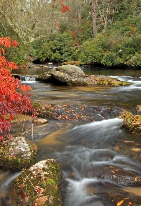
Chattooga River
Georgia, North Carolina, South Carolina
Flowing through three states and the Ellicott Rock Wilderness, the Chattooga is recognized as one of the Southeast's premier whitewater rivers. It begins in mountainous North Carolina as small rivulets, nourished by springs and abundant rainfall. High on the slopes of the Appalachian Mountains is the start of a 50-mile journey that ends at Lake Tugaloo between South Carolina and Georgia, dropping almost 1/2-mile in elevation.
The river is one of the few remaining free-flowing streams in the Southeast. The setting is primitive; dense forests and undeveloped shorelines characterize the primitive nature of the area. No motorized vehicles are permitted within a corridor about 1/4-mile wide on either side of the river. Visitors must rely on their own skills and strength rather than on motorized equipment. Man-made facilities are minimal, consisting primarily of hiking trails.
Designated Reach
May 10, 1974. The segment from 0.8 miles below Cashiers Lake in North Carolina to the Tugaloo Reservoir. The West Fork from its confluence with the main stem upstream 7.3 miles.
Outstandingly Remarkable Values
Ecology
There is a variety and richness of the plant life within the Chattooga Watershed, including the Chattooga River corridor. The unique geography and climate characteristics provide habitats for uncommon assemblages of endemic, disjunct, and relic plant species. The rarest species within the Chattooga River Gorge landtype are the Southern Appalachian endemics, which include the liverworts, rock gnome lichen; Blue Ridge bindweed, Frasera loosestrife, Manhart's sedge, Biltmore's sedge pink shell azeala, and divided leaf ragwort.
Geology
The geologic and geomorphologic values of the Chattooga include the deeply dissected escarpment and the steep, rocky, forested slopes that plunge into deep, narrow gorges. There are a series of outstanding monolithic treeless domes and slopes of exposed resistant granite, which occur at the upper headwaters of the river. Another feature of the river is that it flows into the Atlantic Ocean, whereas most other rivers in the Southern Appalachian flow into the Gulf of Mexico. It is likely that the Tugaloo River (formed by the convergence of Chattooga and the Tallulah) captured these rivers from the Chattahoochee River. A stream capture of this magnitude is unusual in the region.
History
A total of 38 archeological sites have been recorded within the corridor. These include 15 prehistoric sites, 15 historic house and farmstead sites, a railroad embankment, 2 historic cemeteries, a 19th century mineral prospecting pit, and a rock shelter. Approximately half of these sites are considered potentially eligible for the National Register of Historic Places. The Cherokee's village of Chattooga Town was occupied from the early 1600s until the 1730s when it was abandoned. The site is near the present-day Highway 28 Bridge. This site is also eligible for the National Register of Historic Places.
Recreation
The recreation values of the river and corridor are outstanding along its 57-mile course. The river offers a wide variety of activities in a high-quality setting. Activities range from swimming to hiking to horseback riding with spectacular scenery to excellent trout fishing to nationally recognized white-water rafting opportunities. Other activities include backpacking, photography, and nature study. Most of these activities take place in largely unmodified natural surroundings with many opportunities for remoteness and solitude.
Scenery
The scenery along the Chattooga River is exceptional and plays an important part in the wild and scenic river experience. The river is deeply entrenched between high ridges for large stretches of its length. Steep, forested slopes on either side of the river give a feeling of seclusion. The river constantly meanders and curves, and there are excellent views along these bends. The seasons change the landscape from the varying soft greens of spring and summer to a patchwork of red, yellow, and orange. Winter finds the leaves stripped away, and the patches of green from the white pines stand out against the gray-brown hillsides and exposed rock formations. The river itself provides a varying scene from a smooth flowing stream to a river with thundering falls and cascades, raging rapids, enormous boulders, and cliff-enclosed deep pools.
Documents
Classification/Mileage
Video
President Jimmy Carter, an unsung environmental hero, grew up in awe of nature’s wonder. But it wasn’t until he first paddled the Chattooga River’s Bull Sluice that he understood a wild river's power. In celebration of the 50th Anniversary of the Wild & Scenic Rivers Act, President Carter urges all Americans to protect more wild rivers.

