Rogue River
Rogue River
Oregon
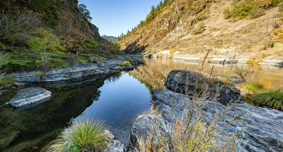
From its source high in the Cascade Mountains in southwestern Oregon near Crater Lake National Park, the Rogue, one of the longest rivers in Oregon, tumbles and flows more than 200 miles, entering the Pacific Ocean at Gold Beach. One of the eight rivers established with passage of the Wild and Scenic Rivers Act in 1968, the designated segment of the Rogue extends from the mouth of the Applegate River (about six miles downstream from Grants Pass) to the Lobster Creek Bridge (about eleven miles upstream from its mouth), a total distance of 84 miles. The first 47 miles are administered by the Bureau of Land Management Medford District, and the remaining 37 miles are administered by the Rogue-Siskiyou National Forest.
The Rogue River is known nationally for its salmon and steelhead fishing and high-quality whitewater boating opportunities.
The lure of gold in the 1850's attracted a numbers of miners, hunters, stocker raisers, and subsistence farmers. Conflicts between white settlers and Native Americans culminated in the 1855-56 Rogue River "Indian War," after which Native Americans were relocated to reservations. For settlers, life in the Rogue Canyon was difficult and isolated. While gold mining operations were extensive, overall production was low. The remnants of mining, such as pipe, flumes, trestles, and stamp mills can still be found.
Designated Reach
October 2, 1968. The segment of the river extending from the mouth of the Applegate River downstream to the Lobster Creek Bridge.
March 12, 2019. Numerous tributary designations:
- Alder Creek from its headwaters to the confluence with the Rogue River.
- Anna Creek from its headwaters to the confluence with Howard Creek.
- Bailey Creek from its headwaters to the confluence of the Rogue River.
- Big Windy Creek from its headwaters to the confluence with the Rogue River.
- The East Fork of Big Windy Creek from its headwaters to the confluence with Big Windy Creek.
- Booze Creek from its headwaters to the confluence with the Rogue River.
- Bronco Creek from its headwaters to the confluence with the Rogue River.
- Bunker Creek from its headwaters to the confluence with the Rogue River.
- Copsey Creek from its headwaters to the confluence with the Rogue River.
- Corral Creek from its headwaters to the confluence with the Rogue River.
- Cowley Creek from its headwaters to the confluence with the Rogue River.
- Ditch Creek from the Wild Rogue Wilderness boundary in T 33 S, R 9 W, Section 5, Willamette Meridian, to its confluence with the Rogue River.
- Dulog Creek from its headwaters to the confluence with the Rogue River.
- Francis Creek from its headwaters to the confluence with the Rogue River.
- Hewitt Creek from its headwaters to the confluence with the Rogue River.
- Howard Creek from its headwaters to the confluence with the Rogue River.
- Jenny Creek from its headwaters to the confluence with the Rogue River.
- Kelsey Creek from the Wild Rogue Wilderness boundary in T 32 S, R 9 W, Section 25, Willamette Meridian, to the confluence with the Rogue River.
- The East Fork of Kelsey Creek from its headwaters downstream to the confluence with Kelsey Creek.
- Little Windy Creek from its headwaters to the confluence with the Rogue River.
- Long Gulch from its headwaters to the confluence with the Rogue River.
- Meadow Creek from its headwaters to the confluence with the Rogue River.
- Missouri Creek from its headwaters to the confluence with the Rogue River.
- Montgomery Creek from its headwaters to the confluence with the Rogue River.
- Mule Creek from its headwaters to the confluence with the Rogue River.
- Quail Creek from the Wild Rogue Wilderness boundary in T 33 S, R 10 W, Section 1, Willamette Meridian, to the confluence with the Rogue River.
- Rum Creek from its headwaters to the confluence with the Rogue River.
- The East Fork of Rum Creek from its headwaters to the confluence with Rum Creek.
- Russian Creek from the Wild Rogue Wilderness boundary in T 33 S, R 8 W, Section 20, Willamette Meridian, to the confluence with the Rogue River.
- Shady Creek from its headwaters to the confluence with the Rogue River.
- Slide Creek from its headwaters to the confluence with the Rogue River.
- Whisky Creek from the confluence of the East Fork and West Forks of Whisky Creek to the south boundary of the non-federal land in T 33 S, R 8 W, Section 17, Willamette Meridian.
- Whisky Creek from road 33–8–23 to the confluence with the Rogue River.
- The East Fork of Whisky Creek from its headwaters downstream to the confluence with Whisky Creek.
- The West Fork of Whisky Creek from its headwaters to the confluence with the East Fork of Whisky Creek.
- Wildcat Creek from its headwaters to the confluence with the Rogue River.
Outstandingly Remarkable Values
Fish
The Rogue River is home to a variety of species, including chinook salmon, coho salmon, steelhead, cutthroat trout, and green sturgeon. The adult fish use the clean river substrate to deposit their eggs. The eggs then remain in the gravel for several months. After hatching, some species such as coho, steelhead, and green sturgeon, rear within the river from one to three years, while others, such as chinook, begin the journey to the ocean and will eventually make their way back to their natal stream to spawn.
It is not uncommon to see black bears, deer, otters, great blue herons, and ospreys looking for a meal of salmon.
Recreation
The Rogue River area sees over a half million visitors each year. Recreation opportunities include driving for pleasure, boating, fishing, guided motorized tour boat trips, guided whitewater fishing and float trips, camping, hiking, swimming, picnicking, wildlife viewing, sunbathing, and gold panning.
Scenery
Surrounding the Rogue River, the rugged and complex canyon landscape of the Wild Rogue Wilderness was partly designed to provide watershed protection for the wild section of the Rogue River. The established boundary assured preservation of a rugged and complex canyon landscape. The area is characterized by steep terrain of near vertical cliffs, razor-sharp ridges, and cascading mountain creeks. Look for diverse flora and fauna among the cliffs and creeks of the Rogue River watershed.
Managing Partners And Contacts
Documents
Classification/Mileage
Video
2015 was the 50-year anniversary of the Wild and Scenic Rivers Act. Passed by Congress and signed into law by President Lyndon B. Johnson, the Wild and Scenic Rivers Act ensures that designated rivers across the USA be protected from dams, over-development, and other obstructions that would keep them from flowing freely. John Williams takes you to several of the Northwest's Wild and Scenic Rivers to show you various accessible recreations.
The River Wild was filmed on several rivers — the Charles River in Cambridge, Massachusetts; Rogue River just outside the town of Medford, Oregon; and the Middle Fork of the Flathead River in Montana all had some footage shot. However, the big rafting action scenes took place on Montana’s Kootenai River. Permission to film in this region was granted for the very first time by the Kootenai Indians who hold this ground to be sacred. There was one caveat to the film crew receiving permission to film here: the actual location where shooting took place was never to be disclosed to the public.
Hang on tight for a suspense-filled action-thriller starring Oscar-winner Meryl Streep in a stunning performance that will take your breath away! Streep portrays a former river guide who arranges a white-water rafting trip to celebrate her son's birthday and salvage her shaky marriage. Her skills and courage are soon put to the test when three mysterious strangers threaten to turn their vacation into a living hell. Also starring Kevin Bacon and David Strathairn, this "pulse-pounding thrill ride" (Rolling Stone Magazine) explodes with action, suspense and unforgettable storytelling from the director of L.A. Confidential.