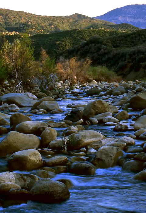
Sespe Creek
California
Sespe Creek is located in Ventura County approximately eight miles north of Ojai, California. Sespe Creek originates in the Santa Ynez Mountains, a part of the California Coast Range, and flows into the Santa Clara River south of Fillmore, California. The designated corridor lies entirely within the administrative boundaries of the Los Padres National Forest. Most of the wild segment lies within the Sespe Wilderness. A portion, approximately seven miles, traverses the Sespe Condor Sanctuary.
Elevations within the watershed range from 1,040 feet at the downstream terminus of the designated wild segment to 3160 feet at the upper terminus at Howard and Rock Creeks. The climate is a temperate, Mediterranean type, typified by warm, dry summers, and cool, moist winters. Precipitation averages 27 inches of rain with approximately 95% falling between November and April.
Designated Reach
June 19, 1992. The main stem from its confluence with Rock Creek and Howard Creek downstream to where it leaves Section 26, Township 5 North, Range 20 West.
Outstandingly Remarkable Values
Fish
Sespe Creek is an historic southern steelhead stream with anadromous runs of both the southern steelhead trout and Pacific lamprey. This stream represents one of the southernmost anadromous fishery habitats in California. The southern steelhead is designated as federally endangered, adding to the need to focus management actions on its protection and enhancement. Non-native introduced fish species are potential threats to native fish and aquatic species.
Geology
Sespe Creek created deep gorges that expose formations of the Topa Topa Mountain Range. Wind and water carved caves, steeply folded multicolored rock outcrops, hot springs, and deep gorges exposing water-worn boulders, and exposures are a significant contribution to the scenic and recreation values. The designated river corridor contains the “type locality” of the Sespe Rock Formation where it was originally defined and named. The impressive Piedra Blanca Formation, which stands out as steeply dipping white cliff forming outcrops, contrasted against the maroon Sespe sandstone and shale, are adjacent to the upper scenic segment of the river corridor.
Recreation
The entire river corridor offers excellent opportunities for solitude, primitive camping, hiking, horseback riding, and other wilderness-oriented activities. There is an established trail system that generally parallels the creek just above the floodplain and that periodically crosses the creek at right angles. A total of six recreation trails, including a National Recreation Trail, either parallel or cross the creek at various locations. The river corridor provides a scenic area with access to water that enhances recreation. The southern portion of the river corridor provides a rare opportunity to traverse approximately 11 miles that has no trail and must be slowly traversed by boulder hopping and swimming through some sections. Side canyons in this section are inside the Sespe Condor Sanctuary where public access is prohibited. The main canyon contains many deep pools.
Access to the Sespe River corridor is somewhat limited due to its largely wilderness setting. The nearest public vehicle access is a trailhead located near Lion Campground at the eastern terminus of the Sespe Road (Forest Route 6N31). The Squaw Flat Road (Forest Route 6N16) provides public access to a trailhead at Dough Flat east of the corridor. Numerous trails access the WSR corridor from the north, south, east, and west. Two hiking and equestrian trails (Forest Trails 22W04 and 20W30) parallel Sespe Creek for part of the length of the corridor.
Scenery
The scenic value of Sespe Creek is associated with the narrow corridor of the creek itself and the contrast of the geologic features, water, and riparian vegetation. These components, in different combinations, create color, size, and shape contrasts that produce outstanding scenery. Most of the length of the creek is natural, undisturbed, and part of a larger area known as the Sespe Wilderness. Vistas that allow wide views of the landscape enhance the contrast of the riparian zone in the river corridor against the expansive chaparral vegetation on steep hillsides to create unique scenery. In the section between Oak Flat and Hot Springs Canyon, a reddish soil and low scrubby vegetation is prevalent. The hillsides south of the creek contain stands of bigcone Douglas fir as well as oaks and maples. The creek includes diverse landforms and vegetation ranging from wider areas to narrow, rocky areas. In the middle and lower portions of the creek, there are rocky areas that include falls and deep pools in the river supporting steelhead trout. Portions of this area are in unusual, deep gorges with picturesque pools. Alder, sycamore, and cottonwood trees also line some of the riparian area and remain cool and green, even in the heat of summer. In the upper portion of the creek, the course of the creek is wider and forms several oxbow turns.
Wildlife
Several threatened, endangered, or rare wildlife species are found in the relatively undisturbed riparian habitat of Sespe Creek and in the adjacent wilderness. The combination of this habitat with the presence of aboveground water for 9-12 months a year and the remoteness of the area constitute an outstanding value for the area. This corridor currently provides habitat for such species as arroyo toad (federally endangered) and California condor (federally endangered).

