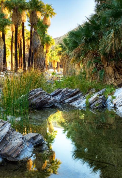
Palm Canyon Creek
California
Palm Canyon Creek, located in the lower eastern slope of the San Jacinto Mountains, is a tributary of the Whitewater River, the primary drainage for the Coachella Valley. It is free of impoundments, is only accessible by trail, and is in a primitive watershed with unpolluted waters. The varied and unspoiled terrain also provides a home for the endangered Peninsular bighorn sheep, the southwestern willow flycatcher, and many sensitive songbirds. The unique presence of California’s only native palm, the California fan palm, gives this canyon its name.
This is the only river in the National System with palm trees as the firest canopy.
Designated Reach
March 30, 2009. From the southern boundary of Section 6, Township 7 South, Range 5 East to the San Bernardino National Forest boundary in Section 1, Township 6 South, Range 4 East.
Outstandingly Remarkable Values
Botany
Palm Canyon supports the largest California fan palm oasis in the United States. The native California fan palms are relics from millions of years ago when the area that is now desert was wetter and occupied by a tropical forest. Today, these trees occur only in locations with a high water table, such as the Palm Canyon oasis, which are adjacent to underground faults that bring water to the surface.
The creek is a nationally significant California palm oasis; the palms are the dominant feature in the overstory of the creek, reaching up to 82 feet tall and 200 years old. The largest stand within the small groves that make up the oasis is about 30 palms. Reproduction occurs only from mature trees and only after extremely wet winters. Fire is also an integral part of the ecology of the palm oases. Fire removes the understory shrubs allowing more water for the fire-tolerant palms and also results in a flush of palm growth as small palms are released from shade. Where fire is allowed to occur, there is a combination of mature trees in the canopy and smaller palms in the understory.
Culture
Palm Canyon holds special significance to the Agua Caliente Band of Cahuilla Indians, the original inhabitants of the area, who continue to care for and protect Palm Canyon. The creek is located in the heart of historic Cahuilla territory and has been a resource for the Cahuilla for over two millennia. The waters of Palm Canyon Creek have sustained the Cahuilla Indians agriculturally, economically, culturally, and spiritually during the entirety of this long period, as they still do today.
There are many Cahuilla sites along the entire portion of the canyon, including village sites, seasonal camps, and numerous specialized activity areas, including rock art, agave roasting pits, and milling features. Evidence exists in the Canyon which reflects all aspects of Cahuilla life and has exceptional human-interest value to the local Cahuilla and tribal community.
The California fan palms themselves are considered ancestors by the Cahuilla Indians.
Scenery
Palm Canyon Creek is characterized by steep slopes and narrow ridges with deep, rugged canyons. The creek bed in Palm Canyon is almost always dry, flowing underground for much of the year. A few short reaches have modest seasonal surface flow, providing havens for small oases. Seasonal variations are not readily apparent, except within the riparian corridor when the willows turn golden before dropping their leaves in the fall. Winter and early spring storms bring ephemeral waterfalls.
The palms themselves are a unique aesthetic resource.

